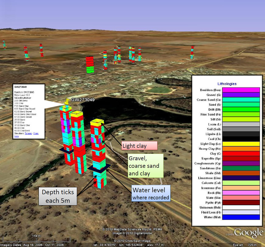
3D Bore Log and Other graphics
Quick effective assessment of available bore data
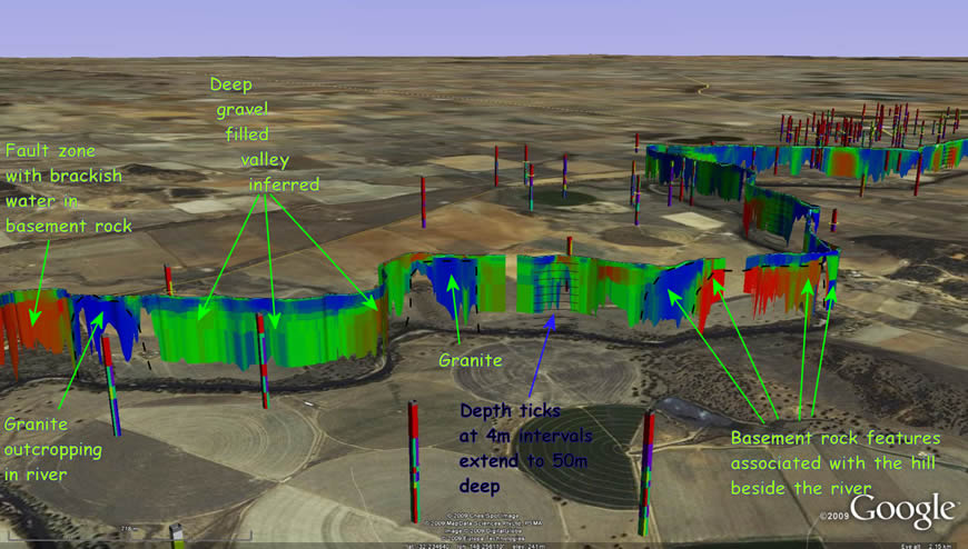
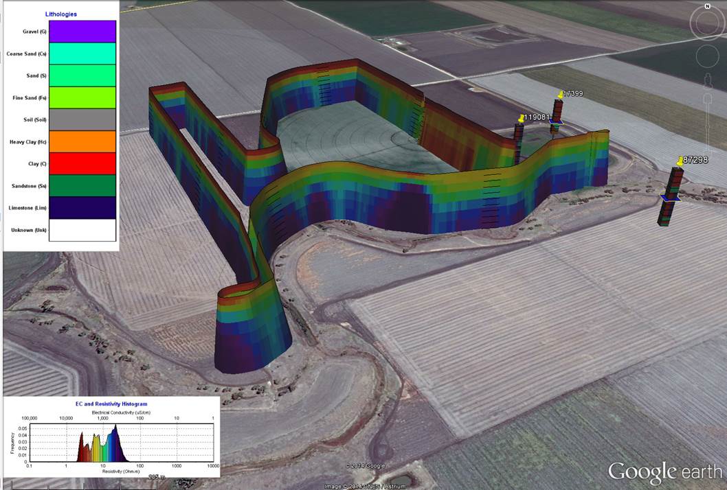
Three dimensional subsurface imaging is now within the grasp of anyone capable of operating Google Earth with the assistance of files we provide. We present drillers logs (lithological logs) from government databases, as well as geophysical data we collect, in 3D graphics of the subsurface. We distribute such graphics to end users as files they can open, superimpose, and manipulate in Google Earth and other 3D viewers. Our geophysical data typically is presented in vertical sections wrapped along the track of our surveys. We call these ribbon, or curtain, images. On occasions, density of data collected warrants presentation of depth slices or more elaborate iso-surfaces.
DRILLERS LOGS – 3D GRAPHICS FROM STATE WATER BORE DATABASES
For anyone siting water bores, we offer graphics of drillers logs from government water bore databases. This solution replaces the frustrating an ineffective method of groundwater investigation whereby one obtains huge lists of text bore summaries with bore coordinates and tries to make sense of their 3D distribution. Our graphical method permits rapid identification of all the most suitable bores for 3D comparison with prospective bore sites.
In our groundwater investigation solution we offer small, compact Google Earth (KMZ) files that can be readily emailed to you then simply opened in Google Earth. Rotate/Tilt and Zoom the drillers logs that appear and click on bore icons to reveal bore particulars. We charge approximately $300 for graphics of 20 to 100 bores – price will be confirmed once graphics are generated. Presently we offer drillers logs 3D Graphics from NSW, Vic & Qld State Water Bore Databases. Other data sources can be accessed upon request.
Download Google Earth Demo Files
Bore Graphics Sample Data
Mid Macquarie Alluvial Valley sample AgTEM data 100m deep HERBI data collected beneath the Lachlan River, Hillston Bore lithology and water level graphics near the Lachlan River, HillstonView up to 100 Bore Logs in Google earth for $300
3D Water Bore Log Graphics orders
To view in Google Earth, for $300 you can obtain a KMZ file of up to 100 bores from an area you select. Additionally you will receive some static views of the KMZ in a power point document along with some indication of their significance to your water search. Please supply co-ordinates of your property by observing the latitude and longitude displayed at the bottom of the Google Earth screen – or more appropriately use the polygon tool in Google Earth to draw around your property boundary and send the KML polygon or a screen capture as an attachment in an email. Should there be few bores to display Groundwater Imaging may choose to reduce the price or refuse to charge for the query.
3D ELECTRICAL CONDUCTIVITY IMAGES
The most cost effective way of looking for groundwater where drill holes are insufficient is electrical conductivity imaging and for this, we provide necessary 3D imaging technology. On occasions, this technology is also useful for mineral exploration.
Our geophysical data typically is presented in vertical sections wrapped along the track of our surveys. We call these ribbon, or curtain, images. They present relevant geophysical data in full geographic context without dressing it up in any way. On occasions, density of data collected warrants presentation of depth slices or more elaborate iso-surfaces. Interpretation of the graphics is conducted in combination with lithological log graphics. We can create ArcHydro Groundwater compliant conceptual models upon request for those that wish to view hydrogeological rather than raw geophysical data.
Troubleshooting Images : Google Earth file specifications occasionally change and are not always backwards compatible. Further, various graphics cards limit viewing in different ways, especially when trying to view in 3D. Insufficient computer memory will cause large datasets to update slowly and eventually crash. We can supply a small program that corrects several backward compatibility issues. We are also aware of a new shading problem where sun angle is applied inconsistently and we have applied a solution to new ribbons – for old ribbons avoid this problem by viewing only from the south or near south or get us to recreate the ribbons. Our new solution is presented below.
Triprismage : Instead of displaying resistivity/depth images just as ribbons, we now display them as continuous triangular prism images wrapping along survey tracks. This greatly enhances Google Earth illumination and makes it possible to view the images in plan view as well is obliquely.
Condamine Triprismage projected 50m up