Time Lapse Moisture Migration Mapping
There are many soil moisture probes and sensors on the market that sample moisture in very isolated volumes of soil and can log these over time but cost effective tools that image changes in soil moisture, in a whole vertical section or even in 3D in the soil are rare.
Movement of moisture and changes in salinity can be imaged over time using our ERT (electrical resistivity tomography equipment) optionally with telemetry. It is useful for monitoring pollutants & for study of irrigation efficiency. A typical agricultural installation will integrate moisture probes and/or Granular matrix moisture sensors within it. Indeed our system, with the Lippmann Geo-resistivity meter at its core can directly measure moisture changes both within numerous granular matrix moisture sensors and between them and strategically placed electrodes set up so as to image, using tomography, a large bulk of soil. The Lippmann Geo-resistivity meter communicates directly with terminal modems to regularly transmit data to the internet.
A typical pollution plume monitoring setup will use the same equipment but with electrodes buried in trenches, typically beneath and beside plastic lined reservoirs containing the pollutants. A reservoir set up with such monitoring in advance is a good idea.
The Lippmann Earth Resistivity Meter can be operated remotely using telemetry. We package such systems for soil moisture change imaging in 2D and 3D at various scales. We also offer it for monitoring seepage of contaminants from lined storages. The Lippmann device directly communicates with modems which we offer. It can also integrate reading of Watermark and temperature sensors into its reading sequence. We also offer integration of capacitive moisture sensors into telemetry equipped monitoring sites.
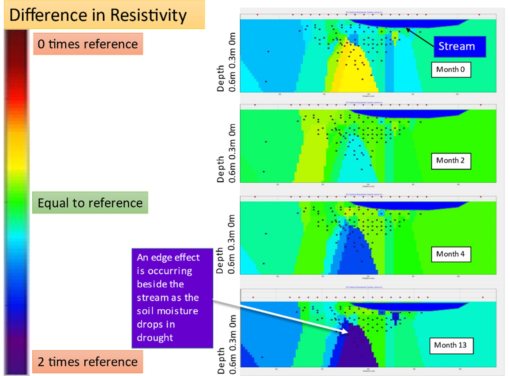
Software is offered that takes 2D and 3D earth resistivity data collected at regular intervals and detects very subtle changes over time. Groundwater Imaging Pty Ltd also offer to apply such software to clients data on their behalf.
Time lapse operation of repeated survey using our Echidna Soil Profiler (LINK) is ideal for resolving deep drainage impact on soil profiles.
Time lapse ERT can be very useful when automatically collected from farm machinery that regularly passes across paddocks. See the following possibilities:
- Soil profiling from an overhead irrigator – every time it moves.
- Soil profiling from a spray rig – every time it moves.
- Deep transect soil change imaging during irrigation events, weather events and water transport and storage events.